"El Niño Costero may be exacerbated by climate change."
José Manuel Gálvez, meteorologist of the National Oceanic and Atmospheric Administration (NOAA) explained to Libélula that El Niño Costero is a phenomenon that manifests itself in a warming of the sea along the coasts of Ecuador, Peru and northern Chile, and that in his opinion could become a global phenomenon.
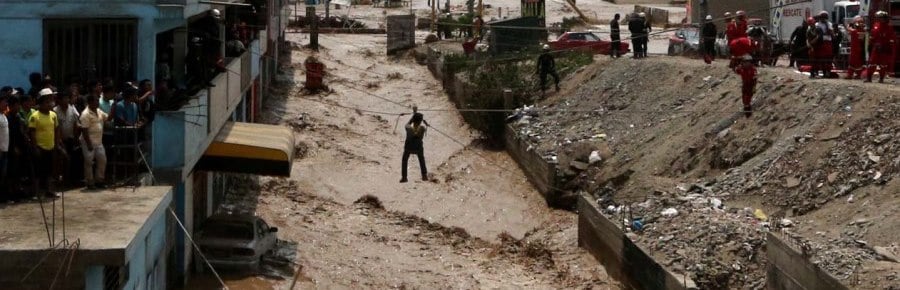
In recent weeks, the weather agenda in Peru has been marked by extreme rains that have caused landslides, landslides, floods, among others, which have left a tragic panorama: more than 120,000 victims, 90 deaths, 164,000 homes affected.
Peruvian José Manuel Gálvez, instructor for methodologies in weather and climate analysis and forecasting for the Americas at NOAA and creator of the Gálvez Davinson Index which improves the detection and forecast of tropical convection, gave an exclusive interview to Libélula to explain the origin of the Coastal Niño and possible alternatives to improve the forecast of this type of phenomena.
How does the “El Niño” phenomenon occur in the Central Pacific and what is the difference with the “Coastal El Niño” currently occurring in Peru?
The name “El Niño” was born in Peru because many years ago it was noticed that there was a current that always came in December that changed the rhythm of fishing and generated a little rain, but eventually (very rarely) this current came very strong, and the sea became very hot. This fact was called the El Niño phenomenon.
In the 1950s and 1960s, the idea of the existence of a global phenomenon that warmed the sea began to take shape. In 1983, there was an El Niño phenomenon that occupied the entire Pacific basin up to the Peruvian coast and, as is historically known, it was the most devastating. Scientists, upon identifying that this was a global event, began to follow it and monitor it for the magnitude of its impacts. Then it occurred in 87, 92 and 97-98.
There are two types of El Niño phenomena: the classic one, which occupies the entire Pacific basin; and the El Niño phenomenon, which occupies the entire Pacific basin. Coastal Niño, which is a warming along the coasts of Ecuador, Peru and northern Chile.
How are the climatological processes of El Niño and El Niño Costero?
The difference between these two phenomena is the processes that occur in the equatorial Pacific. A basin-wide El Niño has a classical formation due to waves Kelvin oceanic. The trade winds - tropical easterly winds - are almost always pushing the water towards the Australian area, but once those winds weaken the water returns. That returning wave is known as an oceanic Kelvin wave, which is sub-surface (below the surface) and is not seen reaching our shores.
It is also necessary to understand the south pacific anticyclone, which is a system of high pressure and relatively strong winds that is in front of our coasts all year round. This anticyclone generates that the masses of cold and stable water (that do not produce rain) come from Chile along the Peruvian coast and reach Paita (Talara). This avoids the generation of rains on the coast and deserts up to Talara. When the anticyclone weakens, during the summer, the lack of wind causes the sea to warm up and allows Kelvin waves to enter.
This phenomenon, which is natural, lasts approximately 1 year. The periodicity is not specific but has a range of 3 to 8 years of occurrence.
The Coastal El Niño is the same as the basin-wide El Niño but lacks the contribution of Equatorial, Kelvin waves and other processes. This year we do not have a basin-wide El Niño, however, the anticyclone has been quite weak and there has also been an inflow of waters with a higher than normal temperature from the south (from the area of Chile) that have been dragged by the current and have reached the coasts of Peru and Ecuador at a critical time, in the transition to summer. It is a local phenomenon of our coast that has been exacerbated by the occurrence of early rains.
And have these sea temperature anomalies occurred before?
Yes, in the 1997 El Niño both phenomena occurred, the equatorial part and the entry of less cold waters from Chile. Another year in which it occurred was in 2001, it did not end up being an El Niño but there was a warming with rains in the north of short duration. And it seems that in 1925 there were catastrophic rains similar to the Coastal El Niño.
What is the relationship between El Niño Costero and climate change?
From my point of view, and according to data from the last 10 years, the sea on a global scale is warming. The effect this has on the atmosphere is that when events like these occur they are likely to be more intense precisely because the sea is going to be warmer. There is a potential for these events to be stronger and exacerbated by climate change, but there is no evidence that climate change will make them more frequent. There is not yet enough accumulated data to draw conclusions.
And why has it affected Ecuador's coasts differently?
In Ecuador the same effects have occurred as in Peru, even there it rains more. The difference is that Ecuador has more infrastructure for rainfall. El Niño Costero has affected Peru, Ecuador and northern Chile, and it is not yet clear if another place is being affected.
In a BBC article explains that the Coastal El Niño could become a global phenomenon. What do you think about it?
I agree. We do not know exactly what is going to happen but there is a potential for it to evolve into a basin-wide El Niño phenomenon because the non-surface currents, which are those that transport the sea temperature felt in the atmosphere, in the tropical Pacific go from east to west, that is, this warming that is on our coasts is going to be transported by the currents towards the center of the equatorial Pacific. The risk is that the rains are activated and if the warming reaches the Pacific basin and the deep convection is maintained, it can become a global event, because this convection is the one that generates the oceanic Kelvin waves.
Will El Niño Costero happen again next year?
In my opinion, it is highly unlikely that an event of this magnitude will occur again next year. Given the magnitude of the current event, it may have an occurrence of 2 to 3 times per century.
What do we need to have better forecasts in Peru?
In general, more data and information are needed. Sub-surface sea temperature data are very important. Also more surface and height stations (balloons that are released into the atmosphere). There is a lack of knowledge of the physical phenomenon because we do not understand it at the level of making a forecast. In science you cannot draw a conclusion with a single event.
Would it have been possible to forecast El Niño Costero ahead of time?
With time yes, but not in the magnitude that is happening, this has surprised us all. From NOAA we saw something coming in December and it was commented. It was mentioned that this year there was a risk of sea warming for Peru and Ecuador and it happened in a much more extreme way.
Photo: DobleLlave.com

← Previous
Next →